The Anatomy of a Catastrophic Collapse
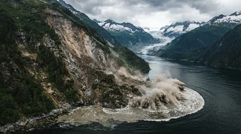
In August 2025, the serene fjords of Alaska became the stage for a geological event of unprecedented scale. Following the departure of a tourist vessel from the South Sawyer Glacier, a massive mountainside collapsed into the water, triggering a tsunami that surged 1,580 feet up the opposite side of the fjord. To put this into perspective, the water climbed higher than the top floor of the iconic Taipei 101 skyscraper, scouring the canyon walls down to bare rock. This event currently stands as the second-highest tsunami recorded in history, serving as a sobering reminder of the volatility inherent in rapidly changing Arctic landscapes.
While the event occurred in the early hours of the morning, avoiding human casualties by sheer luck, it has ignited a fierce debate regarding safety in regions where tourism and geological instability collide. Researchers at the Alaska Earthquake Center have identified that the conditions leading to this disaster—tectonic uplift, accelerated glacial ice loss, and heavy precipitation—are becoming increasingly common, suggesting that this was not a localized anomaly but a broader trend in coastal mountain ranges.
The Precursors of Disaster
Analysis of the Tracy Arm landslide suggests the mountain was not silent in the days leading up to its collapse. Scientists noted a convergence of environmental "red flags" that, had they been monitored, could have potentially allowed for the issuance of proactive warnings. In the two months preceding the slide, the glacier at the base of the mountain retreated by more than one-third of a mile, destabilizing the slope. This physical shift was compounded by heavy rainfall, which infiltrated existing fractures in the mountain, increasing water pressure and pushing the rock mass toward inevitable failure.
Most notably, the area emitted thousands of minor seismic tremors in the days before the event. This activity transitioned into a continuous seismic "hum"—or tremor—in the hours immediately preceding the collapse. These signals act as a fingerprint for impending slope failure, providing a critical window for intervention if integrated into a formal, region-wide detection network.
A Proposed Tiered Alert System
To mitigate the risk in these high-traffic natural zones, researchers are proposing an escalating alert system similar to those used for volcanic activity or forest fire danger. This system would be categorized by color-coded levels of risk:
- Yellow Alert: Issued when conditions like rapid glacier retreat and heavy precipitation are combined with elevated environmental stress, indicating a generally heightened state of danger.
- Orange Alert: Triggered by the detection of specific seismic indicators, such as increasing micro-tremors or the transition into a continuous "hum" of seismic energy. This would signal an immediate risk to mariners and local residents.
- Red Alert: Initiated during the landslide event itself. By using existing seismic wave technology to confirm the size and nature of the landslide within minutes, officials could broadcast warnings to those in the path of the resultant tsunami, potentially providing up to ten minutes of lead time for evacuation or moving to safer ground.
The Future of Arctic Safety
While an alert system cannot eliminate the danger inherent in the Earth's shifting geology, it marks a shift toward responsible coexistence with nature. As climate change continues to alter the structural integrity of mountain ranges globally, the ability to translate geophysical data into actionable information becomes paramount. Tourists and researchers alike will continue to be drawn to the raw, dramatic beauty of the Arctic; however, the tragic potential of these landscapes necessitates a robust, inter-agency commitment to monitoring and early warning communication to ensure that future excursions do not end in catastrophe.